To plot the flight paths of UFO's on a map to possibly identify where they are coming from or going to. Locating possible flight "zones" or frequently used flight paths, and or Hotspots.
In developing this process I've tried to keep the equipment as "affordable" as possible and make the measurements quick and easy. All that is needed is a "Cheap Tube Transit", which can be made for just a few dollars,(and is described below,) a good hiking compass., and a USGS Map. - a GPS Device would further enhance the results.
Hopefully, this procedure will add a new facet to investigating UFO's and improve the credibility of the reports.
If you use these instructions to get measurements on a UFO Flight Path, please send your results to us ASAP so we can work out the Trigonometry formulas to analyze the information, add it to our data base and get some useful results. We will credit your work on final report.
In the Future we might add a Form so you can report your recorded information online. If that would be helpfull please let us know - Contact:
Preliminary
It should be noted that these measurements are estimates only and that they are based on the best reconciliation of what the person experienced. To ensure the best possible measurements, this survey must be taken at the EXACT location that the person saw the object so they will have their original reference points. It should take only take about 10 minutes or less to gather this information.
The "tube" described below is a tool that can be easily made using these details TUBE TRANSIT
Instructions
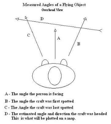
A.Note the general direction the person was facing when first seeing the object (8 points of the compass).
B.Note the estimated height of the object relative to the ground.
1. Below the mountain tops.
2. Approximately mountain top level.
3. Close to the mountain tops (within several hundred feet)
4. Far above the mountain tops.
C.If possible, record the person's latitude and longitude using a GPS device. If that is not possible, locate their approximate location using a 1:24,000 (7.5 Minute) USGS map.
D.Have the person face the direction they first saw the object and note their body angle using a compass. Notes: Whole degrees are OK since this is only an estimate. Also, the difference between magnetic north and true north will be compensated for by adjustments in the latitude and longitude.
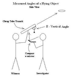
E.Have them look through the "tube" in the direction where they first saw the object. Note the direction with the compass and the altitude angle with the protractor.
F.If the craft made any sudden changes in direction, have them look through the tube at those locations. Note the point of change in directions with the compass and the altitude angle with the protractor.
G.Have the person face the direction they last saw the object and note their body angle using a compass.
H.Have them look through the "tube" in the direction where they last saw the object. Note the direction with the compass and altitude angle with the protractor.
I.Have them hold the "tube" in parallel to the direction where they think the object was last headed. Note the direction with the compass and the angle with the protractor. It should be noted that the perceived angle may be affected by the direction of the flight path.
Hint: For practice, have them hold the tube parallel to the top line of a house, then parallel to the sloping edge of the roof to see if their references are reasonable.
End of instructions.
BELOW ARE SOME HELPFULL PHOTOS SHOWING DETAILS OF DETERMINING ANGLES
CREDIT: UUFOH Member Don Rogers - Investigator
BELOW IS A PHOTOS SHOWING DETAILS OF THE CHEAP TUBE TRANSIT DESCRIBED
Credit : UUFOH Member Don Rogers Investigator
A very easy to make tool using these items:
Viewing Tube:
Cardboard Paper towel tube
Plastic tubing
Other
Hinge:
Cut straw
Cut pen tube
Other
Hinge Pin:
Straightened Hangar
Rod
Other
Protractor:
Best if store bought with detailed measurements/ increments in place.
Plumb Line:
String and weighted anchor
Fishing line, sinker, Other
Glue
As you can see this tool can be made very inexpensively or can be made with high quality materials.
Witness and investigator using the Tube Transit to determine and measure angle of flight
Investigators/ skywatchers can use the Tube Transit tool in the field during or after a sighting
Investigators/ Skywatchers / Researchers
Please send your results to us to be added to our data base.
We will post the results of the analysis reports as soon as we can compile enough data.

 Note the general direction the person was facing when first seeing the object (8 points of the compass).